|
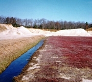
Mason
& Associates provided design development and wetland
permitting services for a large commercial cranberry grower
involved in bog expansion activities. The project included
reconnaissance, inventory, delineation, and mapping of state
and federally regulated wetlands on a 260 acre parcel for
the creation of 35 acres of new bog. Mason & Associates
coordinated interagency review and site walks involving
Rhode Island Department of Environmental Management Divisions
of Freshwater Wetlands, Water Resources, and Agriculture,
U.S. Army Corps of Engineers, U.S. Environmental Protection
Agency, and the U.S. Fish and Wildlife Service.
An
analysis of surficial geological characteristics of the
site, including a hydrological study, was conducted to evaluate
long term water supply and indirect hydrologic impacts to
wetlands. Mason & Associates prepared permit plans and
documentation including design of artificial wetlands for
water quality improvement.
In
response to regulatory agency comments, the firm developed
water quality assessments of nutrient and pesticide loading
to wetlands and receiving waters. Best Management Practices
were developed for a state-of-the-art, efficient, and environmentally
sound agricultural operation. Mason & Associates was
highly praised by the client for the quality and value of
the services provided, and the commitment to meeting project
deadlines. All required permits were obtained in record
time, allowing construction to commence within a few months
of the project's inception. |